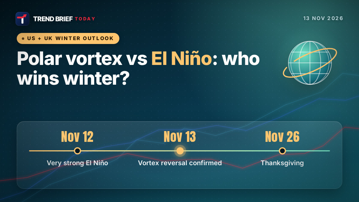
The polar vortex, the ring of strong winds that keeps Arctic air locked over the North Pole, has broken down earlier in the season than ever recorded, just as a very strong El Niño heads for its peak.[1][2][4][5] The vortex breakdown raises the odds of colder spells in the eastern US and northern Europe from late November into early December. El Niño usually pushes the northern US the other way, toward a mild winter.[1][3][4] NOAA's own outlooks, issued on November 12, still lean warmer than normal for most of the US through Thanksgiving week.[8][9] Scientists quoted this week disagree on which force will matter more, and say nobody can be sure yet.[1][2]
 | |
| What happened | Earliest major sudden stratospheric warming on record; vortex winds reversed to easterly[1][4][5] |
|---|---|
| Previous earliest | Late November (28 November); sources differ on the earlier years[1][4][5] |
| El Niño | Strong to very strong; Niño-3.4 at +2.5°C (week of Nov 12)[7][11] |
| Chance of a record El Niño | About 60% (NOAA)[7][12] |
| NOAA, Nov 20-26 | Warmer than normal favored for most of the lower 48[8] |
| Possible cold window | Late November to early December, mostly north and east[1][3] |
| Thanksgiving | Thursday, November 26, 2026 |
| Next NOAA ENSO update | 10 December 2026[7] |
What the polar vortex is
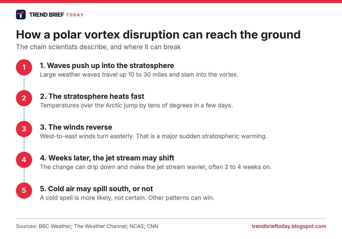
The polar vortex is a band of strong west-to-east winds high above the Arctic, in the stratosphere, roughly 10 to 30 miles up. It forms every autumn as the Arctic goes dark, and while it is strong it keeps the coldest air bottled up near the pole.[1][4][13] It sits above the jet stream, the lower river of wind that steers storms and decides much of the weather people actually feel.[6][13]
Every year or two the vortex is knocked off balance. Big waves in the atmosphere push upward and slam into it, the air over the Arctic heats up by tens of degrees in a few days, and the winds slow down. When they reverse and blow from the east, meteorologists call it a major sudden stratospheric warming, or SSW.[3][4][13] The Weather Channel and Time both put the jump at 50 to 70 degrees Fahrenheit in a few days; NCAS, the UK's atmospheric science centre, says up to 50°C.[2][3][13]
What happened this November
Observations now show the vortex winds have reversed, the BBC's weather team reported on November 13, which makes this the earliest major SSW on record.[4] CNN, The Weather Channel, New Scientist and DW all report the same record.[1][3][5][6] New Scientist says the winds reversed on November 10 and that this beat the old record by 18 days.[5] Most of these events happen in January or February, when the vortex is better established.[1][2][3]
The sources agree the previous earliest came in late November but list different years. CNN says November 28 in 1968 and 2025, the BBC says 28 November in 1969 and 2025, and The Weather Channel lists late November 1958 and 1968, counting from records that start in 1958.[1][3][4] We have not been able to settle which list is right, so we only use the part they agree on.
Scientists from ECMWF, the European forecast centre, told AFP it is "the earliest stratospheric vortex disruption that has been observed", and France's Météo-France called it "an unprecedented event", DW reported.[6] Andrea Lopez Lang, a meteorologist at the University of Wisconsin-Madison, told CNN: "This year is exceptionally unique."[1]
Why so early is not settled. Adam Scaife of the Met Office told New Scientist he suspects "some kind of El Niño influence" but "we don't know that for sure", while Andrew Charlton-Perez of the University of Reading said a blocking high over Scandinavia was "probably more important".[5] Simon Lee of the University of St Andrews told CNN a role for El Niño is possible, "but we're not sure yet".[1]
Is this week's cold snap the polar vortex?
Not directly. A blast of Arctic air reached the eastern US and northern Europe this week, with much of the eastern half of the US running about 7 to 14°F below mid-November averages, CNN and Scripps News reported.[1][14] The BBC says the UK cold spell is "definitely not connected" to the vortex reversal, and New Scientist says the same.[4][5] Effects from the stratosphere usually take a few weeks to filter down.[1][2][13] CNN says this cold should not last long, with above-average temperatures returning to the eastern US next week.[1] We covered the snow that came with it in our first snow and nor'easter explainer.
What El Niño usually means for a US winter
El Niño is a warming of the tropical Pacific that reshapes the jet stream. In a US winter it usually means a stormier, wetter southern tier, from California across Texas and the Gulf Coast to Florida, and a milder, often drier northern tier.[4][11][12][14] NOAA's seasonal outlook from October 15 follows that pattern: warmer than normal favored for the northern tier and the western third of the country for November to January, with wetter than normal favored from California and the Southwest to the Southeast and the eastern seaboard.[10][11]
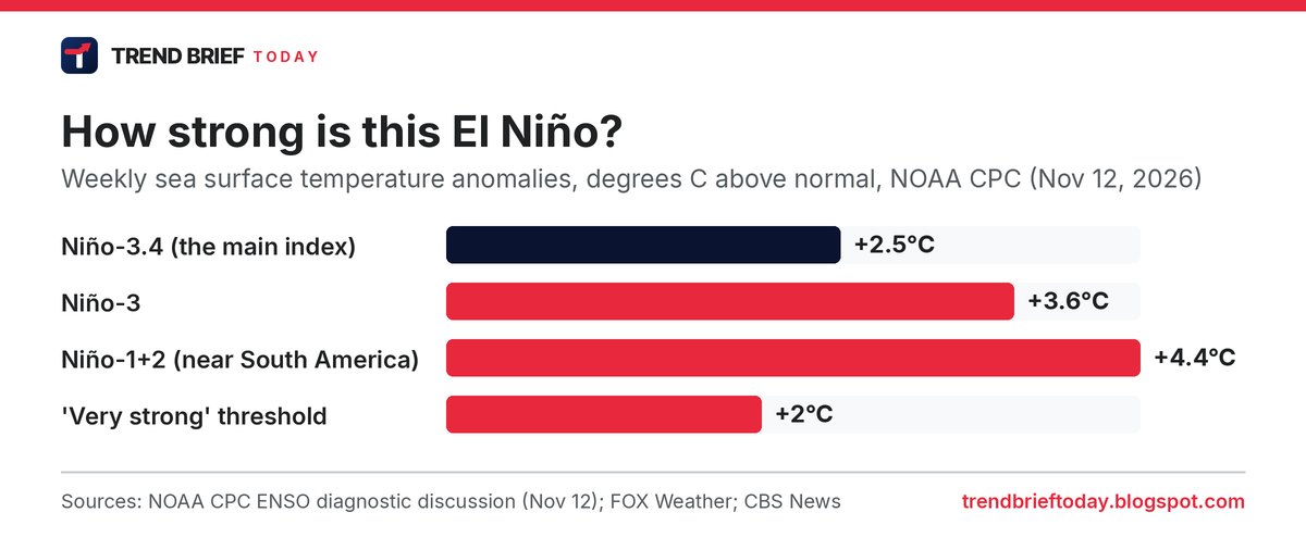
This El Niño is unusually strong. NOAA's Climate Prediction Center said on November 12 that it continues to strengthen, with the Niño-3.4 index at +2.5°C, and gave a better than 79% chance of a strong to very strong El Niño through January to March 2027.[7] It put the chance of a record event, stronger than any since 1950, at about 60%.[7][12] FOX Weather reports that the August to October average crossed the 2.0°C line for a "super" El Niño. CBS News points out that "super" is not an official term; NOAA calls it "very strong".[11][12] The last one this strong was in 2015-16, FOX Weather says.[11]
Polar vortex vs El Niño: which one wins?
This is where the experts split. Lopez Lang called El Niño the "big bully pushing the atmosphere in a certain direction" and told CNN she expects its effect to be "so overwhelming" that any cold will stay within a typical winter. NOAA research physicist Amy Butler told CNN the bigger signal over the next month is "the higher chance of warm temperatures over the northern half of the US, likely related to El Niño".[1]
Judah Cohen, a climate scientist at MIT, sees it differently. He told CNN this week's cold may be the "appetizer", with a higher risk of colder weather in eastern North America and northern Europe in late November or early December.[1] He told Time the vortex event is "not going to determine how our winter is going to be", and that a vortex disruption this big alongside a super El Niño is "uncharted territory".[2]
Two more points cut against a big freeze. Snow cover over North America is the third lowest for the time of year in 28 years, The Weather Channel reports, which leaves less cold air to tap.[3] Jason Furtado of the University of Oklahoma told CNN that winters are warmer on average than a few decades ago, so "everything is relative".[1]

What NOAA says for Thanksgiving week
The Climate Prediction Center's November 12 outlooks favor above-normal temperatures for most of the lower 48 for both November 18-22 and November 20-26, which includes Thanksgiving on November 26.[8] The highest odds of warmth are over the Great Lakes, topping 80% in the 6-10 day outlook and above 60% for the Great Lakes, Northeast and Mid-Atlantic in week two. The West is favored to run colder early on, and parts of the Great Basin and Four Corners near to below normal later. A storm system crossing the southern states is expected to bring wetter weather to the Plains and Mississippi Valley.[8]
The CPC week 3-4 outlook from November 6, covering November 21 to December 4, said the SSW looked "relatively short-lived" in model forecasts and that El Niño was favored to be "the primary influencer". It favored a warmer northern tier and Northeast, with Texas and the Four Corners colder, and noted models hinting at colder air reaching the Southeast in the fourth week.[9] A new week 3-4 outlook was due on the afternoon of Friday, November 13, US time.[9]
The Weather Channel's senior meteorologist Jonathan Erdman reads the same signals a little colder: it "could turn colder for some" in late November, possibly lingering into early December, before it "will probably warm back up for the rest of December".[3] The table below sets the official outlooks side by side.

| Source | Late November view |
|---|---|
| NOAA CPC 8-14 day (Nov 12) | Warmer than normal for most of the US, Nov 20-26[8] |
| NOAA CPC week 3-4 (Nov 6) | El Niño the main driver, SSW short-lived, limited Arctic air[9] |
| The Weather Channel (Nov 12) | Could turn colder for some late Nov into early Dec, then milder[3] |
| Judah Cohen, MIT (CNN, Time) | Higher cold risk in the East late Nov or early Dec[1][2] |
| Amy Butler, NOAA (CNN) | Warmth over the northern US stands out for the next month[1] |
What it could mean for the UK
In the UK, major SSWs have often raised the chance of drier, colder weather with northerly or easterly winds, and of snow in eastern areas, the BBC says. The 2018 "Beast from the East" followed one a few weeks earlier.[4][5] But an SSW does not automatically bring cold, and the Arctic is not yet as cold as it will be by late winter, so any chilly spell may be muted.[4][13] The Met Office stresses that the vortex can nudge the odds but is "not a switch" for cold weather, DW reported.[6]
Dr Matt Patterson of NCAS and the University of St Andrews said snow from this event is "quite unlikely" this early, but drier weather could slow the refill of low reservoirs in southern England.[13] El Niño tends to mean a wetter, stormier autumn and early winter for the UK and a higher chance of cold late in the winter, the BBC says.[4] Scaife told New Scientist the vortex should strengthen again toward the end of November but could break down again, and that "the risk of cold easterlies this winter is increasing".[5]
What to watch next
- The new CPC week 3-4 outlook (issued Friday afternoon US time) and the daily 6-10 and 8-14 day outlooks.[8][9]
- Whether the vortex recovers quickly. NOAA's Butler said this disruption may not have "much staying power", and Lopez Lang said another could follow later this winter.[1]
- NOAA's next ENSO update on 10 December 2026.[7]
- Low snow cover in Canada filling in, which would make any cold outbreak stronger.[3]
Frequently asked questions
Will the polar vortex make Thanksgiving cold?
Probably not for most people. NOAA's November 12 outlook favors warmer than normal temperatures for most of the lower 48 for November 20-26, with the West and Southwest the main exceptions.[8] Some forecasters see a colder turn for parts of the north and east around then, but it is uncertain.[1][3]
Does El Niño mean a mild winter?
For the northern US it usually means milder and often drier; for the southern US it usually means wetter and stormier. It shifts the odds and is not a guarantee.[4][7][11]
What is a sudden stratospheric warming?
A rapid heating of the stratosphere over the Arctic, by tens of degrees in a few days, that weakens the polar vortex. When its winds reverse to easterly, it counts as a major SSW.[3][4][13]
Is the record-early polar vortex caused by climate change or El Niño?
Not known. Scientists quoted by CNN and New Scientist say El Niño may have played a role, but others point to a blocking high over Scandinavia or chance.[1][5]
Will it snow in the UK because of the polar vortex?
Not likely soon. The BBC and NCAS say any effect would take weeks, and snow this early in the season is unlikely. The chance of cold spells later in winter is higher than usual.[4][5][13]
References
- "This winter, it's polar vortex versus El Niño. Round one starts now". CNN. 12 November 2026.
- "What An Early Polar Vortex Combined With El Niño Means For Winter Weather". Simmone Shah, Time. 13 November 2026.
- "Record-early weak polar vortex could chill US by Thanksgiving week". Jonathan Erdman, The Weather Channel. 12 November 2026.
- "The polar vortex just broke a new record but experts aren't sure what it means for this winter's weather". Sarah Keith-Lucas and Ben Rich, BBC Weather. 13 November 2026.
- "Did El Niño cause an early breakdown in the polar vortex?". New Scientist. 13 November 2026.
- "Earliest polar vortex on record arrives: What does it mean for winter?". Natalie Muller, DW. 13 November 2026.
- "ENSO Diagnostic Discussion". NOAA Climate Prediction Center. 12 November 2026.
- "Prognostic Discussion for 6 to 10 and 8 to 14 Day Outlooks". NOAA Climate Prediction Center. 12 November 2026.
- "Week 3-4 Outlook and Prognostic Discussion". NOAA Climate Prediction Center. 6 November 2026.
- "Prognostic Discussion for Long-Lead Seasonal Outlooks". NOAA Climate Prediction Center. 15 October 2026.
- "Super El Niño declared as forecasters warn of major shifts in weather during winter season". FOX Weather. 12 November 2026.
- "What to know as "super El Niño" conditions take shape". CBS News. 12 November 2026.
- "What does the polar vortex mean for the UK's winter weather?". National Centre for Atmospheric Science. 12 November 2026.
- "Polar vortex could disrupt forecast for a warmer El Niño winter". Scripps News. 12 November 2026.