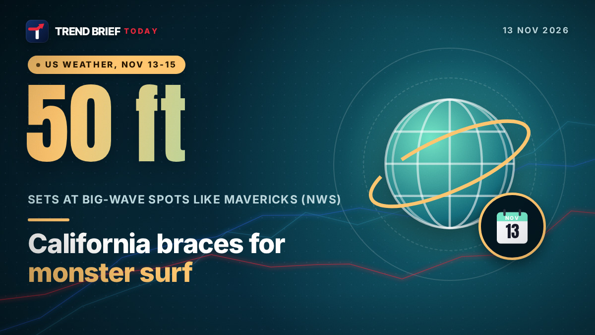
California's coast is under High Surf Warnings from Friday, November 13, 2026, into early Sunday, with breaking waves of 25 to 35 feet on the San Francisco Bay Area coast and occasional sets of 40 to 50 feet at big-wave spots such as Mavericks.[1][2][3] Waves of 30 to 40 feet are forecast on the Del Norte coast in the far north, and 18 to 25 feet in San Luis Obispo and Santa Barbara counties.[1] The surf arrives with the first of two or three storms that will bring the season's first statewide rain and heavy snow to the Sierra Nevada.[2][3]
 | |
| Dates | Friday, November 13, to Monday, November 16, 2026, with a third storm possible mid-week[1][2] |
|---|---|
| Biggest waves | Sets of 40 to 50 ft at favored breaks, Bay Area coast[1][2] |
| Bay Area surf | 25 to 35 ft, 6pm Friday to 4am Sunday PST[1][2] |
| Far North Coast | 30 to 40 ft (Del Norte), 30 to 35 ft (Humboldt)[1] |
| Southern California | 7 to 12 ft in LA on Saturday, 5 to 9 ft in Orange County and San Diego[1][5] |
| Coastal flooding | Warning for the SLO and Santa Barbara coast on Saturday; advisories in San Francisco and Humboldt Bay[1][2] |
| Sierra snow | About 12 in above 7,000 ft at Tahoe, up to 20 in on the crest[1][6] |
| Rain | Up to 6 in on the North Coast over the week, up to 2 in in the Bay Area, under 1 in in LA[3][5] |
| Atmospheric river? | No, says the NWS Bay Area office[2] |
How big will the waves be?
The biggest numbers are for the San Francisco Bay Area. The National Weather Service office there has a High Surf Warning for the coastal North Bay, including Point Reyes, the San Francisco Peninsula coast and northern Monterey Bay, with "dangerously large breaking waves of 25 to 35 ft, with occasional sets of 40 to 50 ft at favored breakpoints."[1] KQED, quoting the same forecasters, names Mavericks on the San Mateo County coast as one of the spots where 50-foot waves could show up.[2] The New York Times also puts the top of the range at 50 feet.[3]
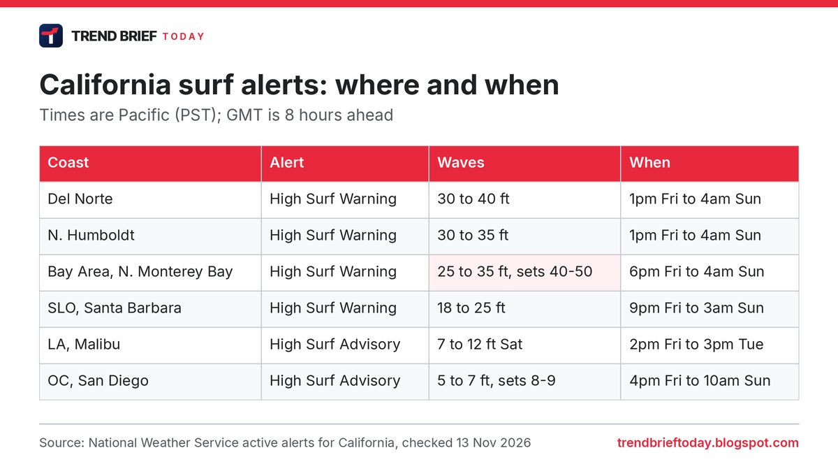
The warnings run along almost the whole coast north of Point Conception. In the far north, the Eureka office expects breakers of 30 to 40 feet on the Del Norte coast and 30 to 35 feet in northern Humboldt County. Farther south, the Los Angeles office has a warning for 18 to 25-foot waves on San Luis Obispo and Santa Barbara County beaches from 9pm Friday.[1]
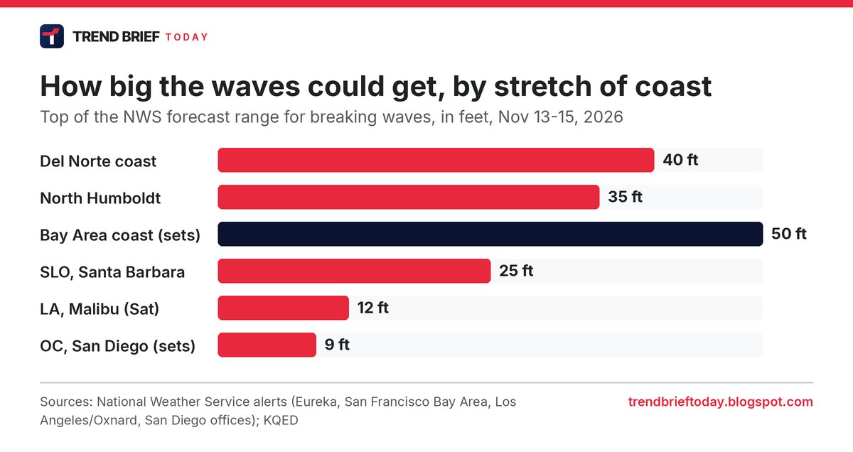
Southern California gets smaller but still dangerous surf. A High Surf Advisory for the Malibu coast and Los Angeles County beaches starts at 2pm Friday, with waves of 4 to 7 feet growing to 7 to 12 feet on Saturday, and runs to Tuesday afternoon.[1][5] In Orange County and San Diego, forecasters expect 5 to 7-foot breakers with sets to 8 or 9 feet at west-facing beaches from 4pm Friday.[1]
Surfers have been riding unusually big swells for more than a week. Waves of 10 to 15 feet started showing up at San Francisco's Ocean Beach last week, and the forecasting site Surfline was predicting swells of up to 35 feet in the city this weekend, the San Francisco Standard reported.[4]
When is the surf at its worst?
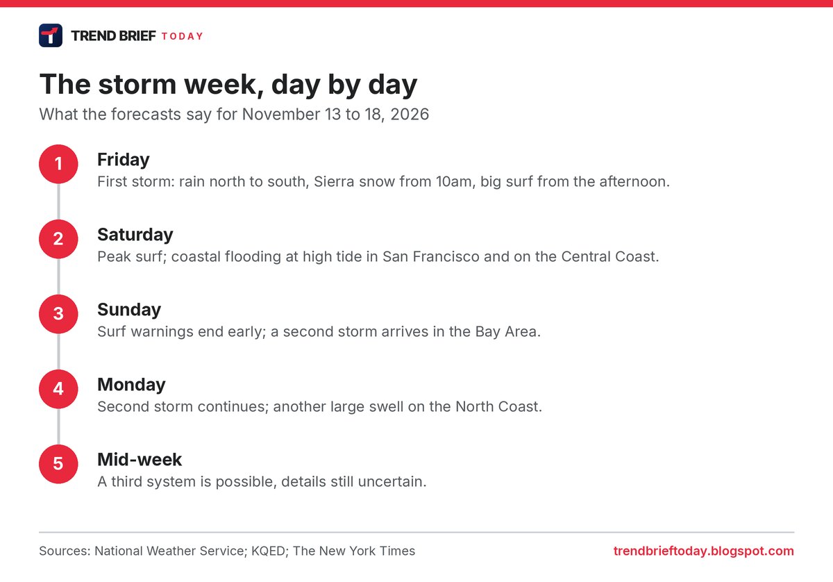
Most warnings start on Friday afternoon or evening and end early on Sunday. In the Bay Area the warning runs from 6pm Friday to 4am Sunday Pacific time, which is 02:00 GMT Saturday to 12:00 GMT Sunday.[1][2] That makes Saturday the day to stay away from the shoreline. It is also the day of the highest tides, which is why coastal flood alerts cover Saturday in San Francisco and on the Central Coast.[1]
The break will be short. The Eureka office says that after "only brief improvement late Saturday through Sunday, a second large swell is forecast late Sunday through Monday."[1]
Will there be flooding?
Along the shore, yes, in places. The Los Angeles office has a Coastal Flood Warning for San Luis Obispo and Santa Barbara County beaches from 3am to 6pm on Saturday and says "significant coastal flooding" is expected. Around Humboldt Bay, high tides could put 1.5 to 2.2 feet of seawater over low-lying ground on Friday afternoon, and in the Bay Area large waves are expected to "run up beaches and crash over seawalls."[1]
Daniel Swain, a climate scientist with UC Agriculture and Natural Resources, said in his YouTube office hours on Thursday that a storm surge of about a foot could add to the waves, so "they're going to be breaking higher and farther inland and causing more erosion than usual," KQED reported.[2] The Times says the ocean off California is unusually warm and El Niño is getting stronger, which tends to raise sea levels along the coast.[3]
Inland flooding is less likely. Roger Gass, a meteorologist at the NWS Bay Area office, told KQED that these are not atmospheric rivers because they are fast-moving and are not expected to stall: "We are not expecting widespread flooding as we are not seeing this system stalling over any given region, so it should be mostly beneficial."[2]
Rain, wind and Sierra snow
The first storm brings rain to most of the state on Friday. The heaviest totals over the next week are expected on the North Coast, up to six inches, while the Bay Area could see up to two inches and Los Angeles less than one, according to The New York Times.[3] For Friday alone, the NWS expects up to 1.2 inches in the North Bay and up to 0.8 inches elsewhere in the Bay Area.[2] FOX 11 Los Angeles, citing the NWS, puts the two-storm total for most of Los Angeles and Orange counties at a quarter of an inch to an inch.[5]
In the mountains it is a proper winter storm. NWS Reno has a Winter Storm Warning for the greater Lake Tahoe area from 10am Friday to 10am Saturday: about 12 inches of heavy, wet snow above 7,000 feet, up to 20 inches along the crest west of the lake, and gusts of 70 to 90 mph over the ridges.[1] South Tahoe Now reported the upgrade from a watch to a warning.[6] Farther south, a warning for Yosemite, Kings Canyon and Sequoia above 6,000 feet runs until 4am Tuesday, with up to 18 inches of snow.[1]
Wind is the other problem in the north. A High Wind Warning on the Del Norte coast covered gusts of up to 60 mph until 1pm Friday, and the Medford office warned of gusts to 70 mph in Siskiyou County's Shasta Valley, which includes part of Interstate 5.[1]
How to stay safe at the beach
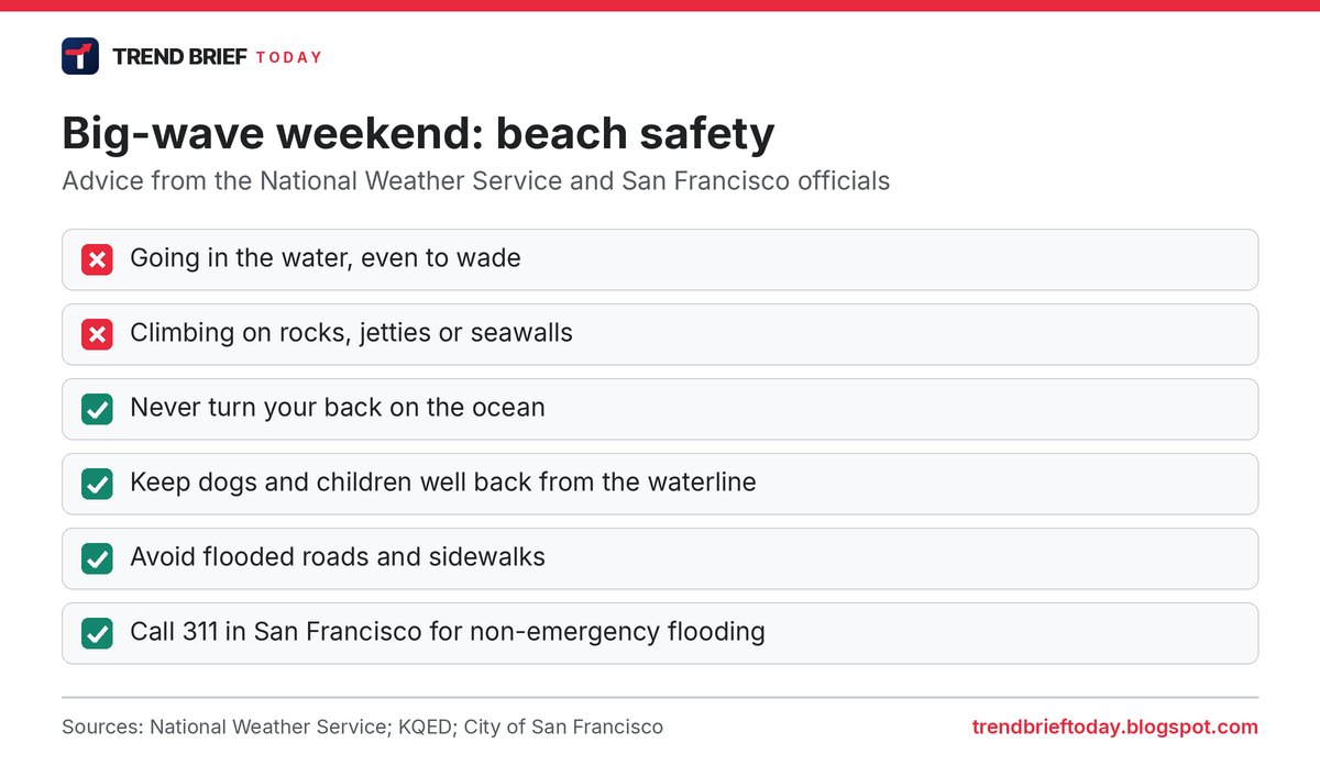
The forecasters' advice is blunt. "The risk of drowning is very high this weekend," the Bay Area office wrote. "Do not go in the water, avoid climbing on the rocks or leaning over seawalls and never turn your back on the ocean."[2] The NWS alerts warn that breaking waves "can sweep people off jetties and docks" and that sneaker waves and rip currents can drag people or pets into the sea.[1][2]
San Francisco told residents to "avoid flooded roads and sidewalks" and "stay out of the water," and to call 311 for non-emergency flooding, blocked drains or fallen trees, KQED reported.[2]
What comes next
A second storm is due on Sunday and Monday. The NWS Bay Area office said the pattern "looks to be broadly similar to Friday's system," and a third system could follow by the middle of next week, although the details are uncertain.[2] Swain told KQED that the second half of November could be very wet for Northern California, with anywhere from 2 to 10 inches of rain possible in the Bay Area.[2]
Wave heights and times in this article come from National Weather Service alerts that were active when we checked them on November 13. Alerts are updated often, so use your local NWS office page for the latest.
Frequently asked questions
Will California really get 50-foot waves?
Possibly, but only as occasional sets at favored big-wave spots on the Bay Area coast, such as Mavericks. The general forecast there is 25 to 35 feet.[1][2]
When do the big waves hit San Francisco?
The High Surf Warning runs from 6pm Friday, November 13, to 4am Sunday, November 15, Pacific time, with Saturday the worst day.[1][2]
Is this an atmospheric river?
No. NWS meteorologist Roger Gass told KQED the storms are moving too fast and are not expected to stall over one area.[2]
How much snow will Lake Tahoe get?
About 12 inches above 7,000 feet from Friday morning to Saturday morning, with up to 20 inches on the crest west of the lake.[1][6]
Will Los Angeles get big waves?
Smaller ones. The NWS expects 7 to 12-foot breakers on Los Angeles County beaches on Saturday, under a High Surf Advisory that lasts until Tuesday.[1][5]
References
- "Active alerts for California", National Weather Service (offices in Eureka, San Francisco Bay Area, Los Angeles/Oxnard, San Diego, Reno, Hanford, Sacramento and Medford). Checked 13 November 2026.
- "'Enormous Waves' and Triple Storms Target Greater Bay Area Starting Friday", KQED, 12 November 2026.
- "California Could Face 50-Foot Waves as Storms Slam Its Coast", The New York Times, 12 November 2026.
- "'Surfing into the apocalypse': Monster waves are arriving and surfers are stoked", The San Francisco Standard, 12 November 2026.
- "SoCal storm timeline: Back-to-back systems bring rain, high surf through Sunday", FOX 11 Los Angeles via Yahoo News, 11 November 2026.
- "Wind advisory and storm warning issued for Lake Tahoe Basin ahead of two storms", South Tahoe Now, 12 November 2026.