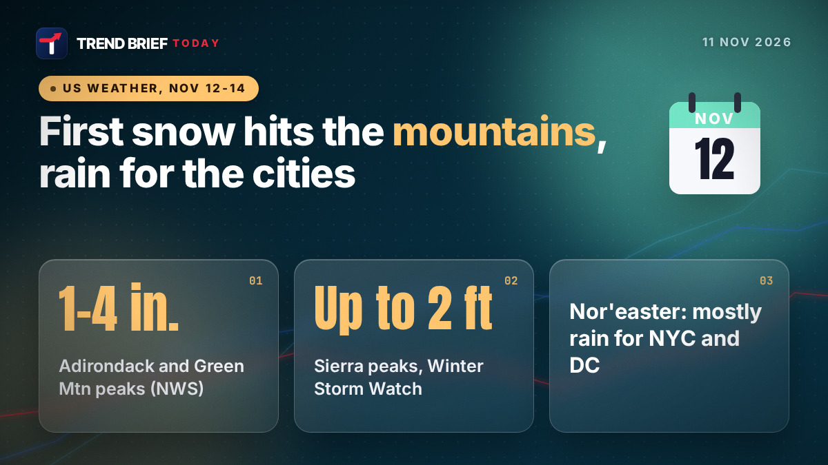
The first snow of the season is on the way for parts of the northern and eastern US from Thursday, November 12, but the National Weather Service expects it to be a mountain event. A storm crossing the Ohio Valley will turn into a coastal low off the Mid-Atlantic, bringing mostly rain and wind to New York, Philadelphia and Washington, with wet snow on the high peaks of New York and New England. The heaviest snow this week is forecast out West, where a Winter Storm Watch covers the Sierra Nevada and Lake Tahoe from Friday.[1][2][7][9]
 | |
| Type | Ohio Valley low becoming a coastal low (nor'easter), then an early-season cold snap |
|---|---|
| East Coast timing | Thursday Nov 12 to early Saturday Nov 14 |
| City impact | Mainly rain, gusty wind, minor coastal flooding at high tide |
| First snow (East) | Adirondacks, Green and White Mountains, Michigan U.P., high terrain of WV |
| Highest East totals | 1-4 in. on Adirondack High Peaks and Green Mountain spine (NWS Burlington) |
| West | Winter Storm Watch, Sierra Nevada and Lake Tahoe, from Friday Nov 13 |
| Sierra totals | About 1 ft above 6,000-7,000 ft, up to 2 ft on the highest peaks |
| Cold | Hard freeze forecast to reach the South this weekend |
| Forecaster | NWS Weather Prediction Center and local NWS offices |
Where and when it will snow
The setup starts on Wednesday, November 11. A low and a strong cold front move from the Midwest into the Ohio and Tennessee valleys, with showers and a few thunderstorms ahead of the front. On Thursday the low crosses the Appalachians and a second low forms off the Mid-Atlantic coast, then strengthens as it moves northeast on Thursday night. That is the nor'easter people have been talking about.[1][9]
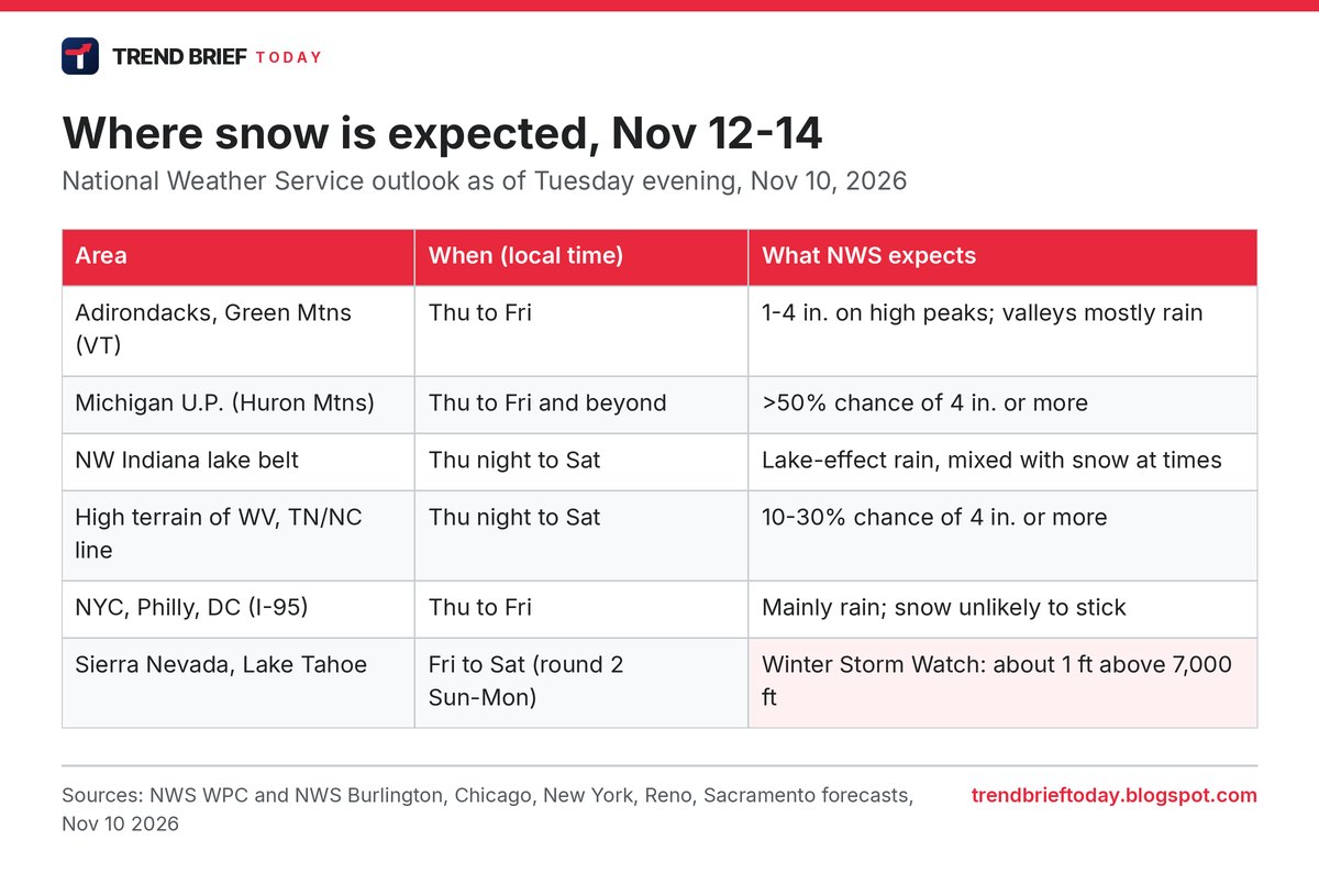
The snow comes on the cold side of that storm. The Weather Prediction Center (WPC) expects light to modest snow over the higher ground of the Adirondacks and into the Green Mountains of Vermont and the White Mountains of New Hampshire. Above about 3,500 feet, it puts the chance of at least 4 inches at better than 50%.[2] The Burlington, Vermont, office is a little more cautious: it currently has 1 to 4 inches for the Adirondack High Peaks and the spine of the Green Mountains on Thursday and Friday, with valleys getting mostly rain.[4] FOX Weather's forecast centre also points to northern New York, Vermont, New Hampshire and Maine as the best bets for snow that actually sticks.[9]
Behind the storm, cold northwest winds will squeeze out more snow on the western slopes of the central Appalachians from Thursday night into Saturday, mainly above 3,000 feet. WPC gives the high terrain of West Virginia and the Tennessee and North Carolina border a 10% to 30% chance of reaching 4 inches.[2][3]
| When (ET) | When (GMT) | What happens |
|---|---|---|
| Wed Nov 11, afternoon and evening | Wed 17:00 to Thu 03:00 | Cold front, showers and storms in the Ohio and Tennessee valleys |
| Thu Nov 12, afternoon | Thu 17:00 onward | Rain spreads into the Mid-Atlantic and New York area; coastal low forms |
| Thu night to Fri Nov 13 | Fri 02:00 to Fri 23:00 | Wet snow on high peaks of NY and New England; rain in valleys and cities |
| Fri night to Sat Nov 14 | Sat 01:00 to Sat 17:00 | Storm pulls toward the Canadian Maritimes; upslope snow showers; winds pick up |
| Weekend | Sat to Sun | Coldest air of the season so far; hard freeze into the South |
Times in the table are rounded from the NWS New York and WPC discussions, which give windows such as "Thursday afternoon through Friday afternoon" rather than exact hours.[1][5]
Will it snow in New York, Philadelphia or DC?
Probably not in any way you would notice. The New York office of the National Weather Service says the chance of rain and snow is highest from Thursday afternoon to Friday afternoon. Wet snow could mix in only on high ground well north of the city, more likely on Friday night, and any accumulation there would be minor.[5] FOX Weather reaches the same conclusion for the whole I-95 corridor: snow that mixes in near the coast is unlikely to stick because there is not enough cold air.[9] The New York Times put it plainly in its Tuesday headline: cold temperatures, but heavy snow is unlikely.[14]
The bigger issue for the coast is water. A new moon on November 9 plus onshore winds could push tides 1.5 to 2.5 feet above normal in the most exposed spots, such as the back bays of western Long Island's south shore and the southwest Connecticut coast, which is roughly the level for minor flooding on Thursday and Friday daytime high tides. NWS New York does not expect rainfall flooding or advisory-level wind gusts.[5][1]
Chicago and the Great Lakes: lake-effect snow
As cold air rushes over the still-warm Great Lakes, lake-effect bands will start on Wednesday night. WPC says Michigan's Upper Peninsula is the coldest spot, with several inches likely from Thursday into Friday, and a better than 50% chance of at least 4 inches over the Huron Mountains away from the lake shore.[2][1]
For the Chicago area, NWS Chicago expects a long spell of lake-effect showers, mixed with snow at times, aimed mainly at northwest Indiana from Wednesday night into Saturday. The band could wobble west at times, but the air coming off the lake is milder than last November, which limits how much snow can settle.[6] NBC 5 Chicago notes that some models show 6 inches or more for parts of northwest Indiana, while others keep it mostly rain, and that Will and Kankakee counties could catch the band if it shifts.[11] FOX 32 Chicago thinks the city itself will likely miss out, with LaPorte and Berrien counties most at risk.[12]
If even a few flakes are seen at O'Hare, it would be Chicago's first snow since March 18. NBC 5, citing NWS records, says the first trace usually falls around Halloween, the latest first trace on record was December 5, 1999, and the average date of the first measurable snow (0.1 inch or more) is November 18.[10]
The Sierra Nevada: the week's biggest snow
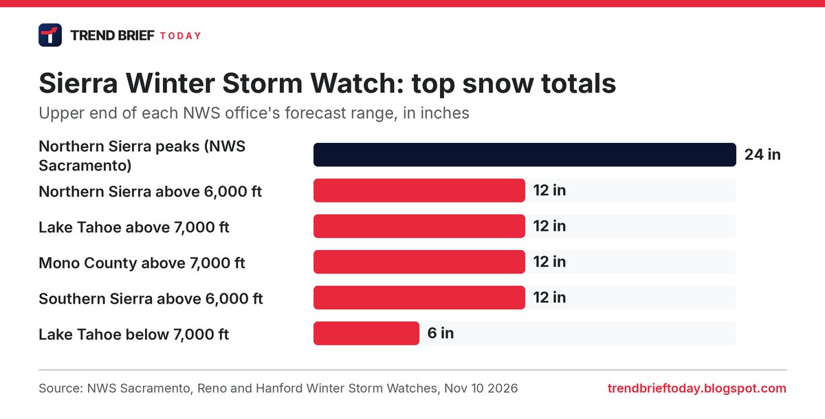
While the East gets the headlines, the West has the real snowstorm. Three NWS offices have issued Winter Storm Watches for the Sierra Nevada. NWS Sacramento expects up to a foot above 6,000 feet and up to 2 feet on the highest peaks of the northern Sierra and Lassen, from Friday morning to Monday afternoon, with gusts up to 60 mph on routes including Interstate 80 and US-50.[7] NWS Reno has about 12 inches above 7,000 to 7,500 feet for the Lake Tahoe area and Mono County from Friday into Saturday morning, with ridge gusts of 60 to 80 mph.[7][13] Reno's KTVN adds that a second, colder and weaker round should follow from late Sunday into Monday.[13]
WPC's extended outlook backs this up: one front brings 1 to 2 inches of rain to the lowlands from northern California to western Washington on Friday, then a colder second front lowers snow levels in the Sierra.[3] The Mercury News and the Sacramento Bee both flagged the Tahoe watch on Tuesday.[17]
How to read NWS winter alerts
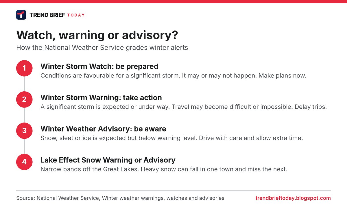
The National Weather Service uses three main levels. A Winter Storm Watch means conditions are favourable for a significant storm, so it is time to prepare. A Winter Storm Warning means a significant storm is expected or happening and travel may become difficult or impossible. A Winter Weather Advisory covers snow, sleet or ice that is a nuisance but below warning level.[8] Each local office sets its own snowfall thresholds, so the amount that triggers a warning in the Northern Plains is much higher than in the Southeast.[8]
As of Tuesday evening, the Sierra alerts were still watches. None of the East Coast offices had issued snow alerts for this storm, which tells you how marginal the eastern snow is.[7][5]
What is a nor'easter?
A nor'easter is a storm that tracks up the East Coast, usually just offshore. It gets its name from the strong northeasterly winds it drives onto the coast. This week's version follows a classic path: an inland low hands its energy to a new low near the Mid-Atlantic coast, which then deepens as it moves toward New England and Canada.[1][5] What it lacks is deep cold air, which is why rain wins in the cities. NWS New York also notes that this storm does not strengthen quickly until it is well northeast of the city, keeping winds there below advisory level.[5]
The cold snap that follows
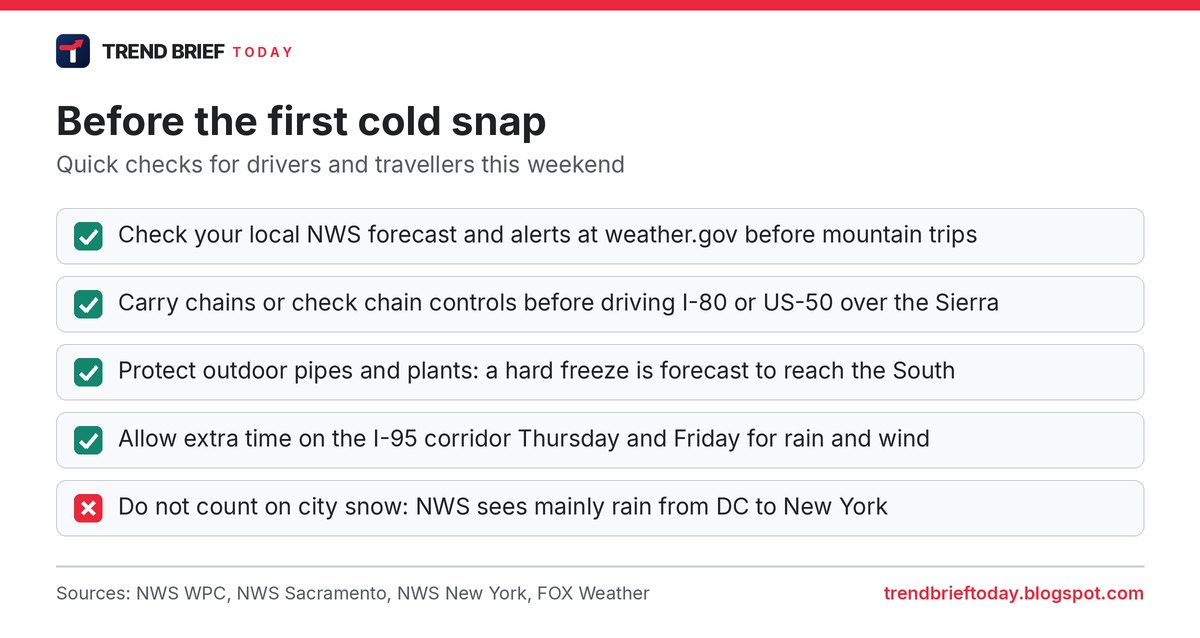
The more widespread story is the cold. WPC expects the coldest air of the season so far across much of the central and eastern US by late week, with highs in the 40s over much of the Midwest and lows in the 20s on the northern Plains by Friday morning. Several places will get their first freeze, and a widespread hard freeze is forecast to reach into the South this weekend.[1] FOX Weather says about 160 million people are expected to see below-average temperatures on Saturday, and more than 110 million in the Northeast and nearby areas will have afternoon highs in the 30s behind the storm.[9] NWS New York has temperatures about 5 degrees below normal from the weekend into Tuesday.[5]
The same flip is happening across the Atlantic: the UK has its first cold-health alert of the winter this week (see UKHSA cold-health alert, November 2026). For drivers, colder weather comes as pump prices ease; see gas prices fall below $4 a gallon.
Canada and the polar vortex
Canadian forecasters are watching the same pattern. The Weather Network has flagged first-snow chances for southern Ontario, and Cult MTL reports that Montreal could see its first flakes on Thursday and Friday.[15][16] Separately, The Weather Network and FOX Weather both report that the stratospheric polar vortex has been disrupted unusually early this autumn.[15][9] That can raise the odds of cold outbreaks in the weeks after, but it does not cause this particular storm, and forecasters say it is too early to call the rest of the winter.
What to watch
- Whether the coastal low tracks closer to the coast on Thursday, which would bring more wind and rain to New England.[1]
- Whether the Sierra watches are upgraded to Winter Storm Warnings before Friday.[7]
- Where the Lake Michigan band settles on Thursday night: northwest Indiana or further west into Illinois.[6][11]
- Freeze warnings in the South this weekend.[1]
Frequently asked questions
When is the first snow of the season in 2026?
For the Northeast mountains and Michigan's Upper Peninsula, Thursday November 12 into Friday November 13. Most big East Coast cities are forecast to get rain.[2][5]
How much snow will fall?
NWS Burlington has 1 to 4 inches on the Adirondack High Peaks and the Green Mountain spine. In the Sierra Nevada, watches call for about a foot above 6,000 to 7,000 feet and up to 2 feet on the highest peaks.[4][7]
Will it snow in Chicago?
Possibly a few flakes mixed with rain, but the lake-effect band is expected to favour northwest Indiana, and NWS Chicago does not expect much accumulation in the city.[6][12]
Is this storm a nor'easter?
Yes, in the sense that a coastal low forms off the Mid-Atlantic and moves northeast. It is expected to be a modest one for the cities, bringing rain, some wind and minor tidal flooding.[1][5]
What is the difference between a winter storm watch and a warning?
A watch means a significant storm is possible, so prepare. A warning means it is expected or under way, so act and delay travel if you can.[8]
References
- "Short Range Forecast Discussion". NWS Weather Prediction Center. Issued 2:55 PM EST, November 10, 2026.
- "Probabilistic Heavy Snow and Icing Discussion". NWS Weather Prediction Center. Issued 3:55 PM EST, November 10, 2026.
- "Extended Forecast Discussion". NWS Weather Prediction Center. Issued 3:04 PM EST, November 10, 2026.
- "Area Forecast Discussion". National Weather Service Burlington, VT. Issued 6:58 PM EST, November 10, 2026.
- "Area Forecast Discussion". National Weather Service New York, NY. Issued 7:05 PM EST, November 10, 2026.
- "Area Forecast Discussion". National Weather Service Chicago/Romeoville, IL. Issued 5:20 PM CST, November 10, 2026.
- Winter Storm Watches for the Sierra Nevada, Lake Tahoe and Mono County. National Weather Service Sacramento, Reno and Hanford (via api.weather.gov). Checked November 11, 2026.
- "Winter Weather Warnings, Watches and Advisories". National Weather Service. Checked November 11, 2026.
- "Potential for nor'easter increasing, could bring first snow to millions as cold air sweeps across the East". FOX Weather. November 10, 2026.
- "When does the Chicago area typically see its first trace of snow?". NBC 5 Chicago. November 9, 2026.
- "Could history repeat itself with lake-effect snow in northwest Indiana?". NBC 5 Chicago. November 10, 2026.
- "Chicago weather: Colder stretch ahead as snow chances shift toward 'Michiana'". FOX 32 Chicago. November 10, 2026.
- "Winter Storm Watch begins Friday". KTVN 2 News Reno. November 10, 2026.
- "Northeast Storm To Bring Cold Temperatures, But Heavy Snow Is Unlikely". The New York Times. November 10, 2026.
- "Winter weather knocking on southern Ontario doorsteps with first snow" and "Polar vortex is on the brink of a historic reversal. What now, Canada?". The Weather Network. November 10, 2026.
- "First snowfall of the season forecast for Montreal on Thursday and Friday". Cult MTL. November 10, 2026.
- "Winter storm watch in place for the Greater Lake Tahoe Area for Friday and Saturday". The Mercury News. November 10, 2026. Also "Winter storm watch in place for Lake Tahoe for Friday and Saturday". Sacramento Bee. November 10, 2026.