Snow is forecast this weekend in the UK, but mainly on the hills of northern Scotland, from late Saturday into Sunday, after the coldest night of the autumn so far brought -6.6C to Sennybridge in Powys.[1][2][3] The Met Office says next week stays unsettled and cold, with rain, sleet and mostly hill snow, while England and Wales start Saturday frosty, dry and bright.[3][5][8] Update, Sunday night: the bigger snow risk is now early Tuesday, when a yellow Met Office snow warning covers northern England, parts of the Midlands and southern Scotland.[13][14]
 | |
| Cover photo: Alan Reid, CC BY-SA 2.0, via Wikimedia Commons. The cover image is shared under the same licence (CC BY-SA 2.0). | |
| Coldest so far | -6.6C, Sennybridge, Powys (Thursday night)[1][2][3] |
|---|---|
| Friday night | Lows of -4C to -6C forecast[2][3] |
| Snow | Mainly hill snow, northern Scotland, Saturday night and Sunday[2][3][5] |
| Next week | Rain, sleet and mainly hill snow, often windy[5][7][8] |
| Health alert | New yellow alert, North West, North East and Yorkshire, 21:00 Sun Nov 15 to 09:00 Thu Nov 19[11][12] |
| Weather warnings | Yellow ice, 18:00 Sun to 10:00 Mon; yellow snow, 00:00 to 12:00 Tue Nov 17[13][14] |
Will it snow this weekend?
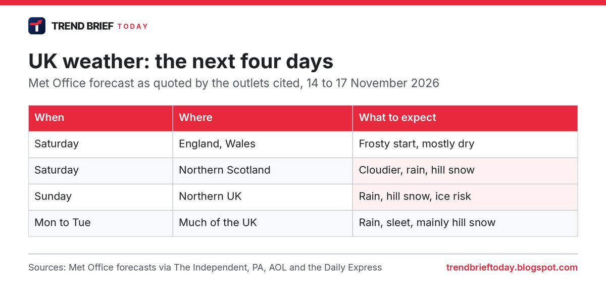
Yes, but mostly on high ground in Scotland. The Met Office forecast for Saturday reads: "Largely fine and dry for England and Wales, although cloudier than previous days. Cloudier in northern Scotland with some rain and hill snow. Showers reaching southwest England later. Feeling cold."[5][8]
Sunday is the day to watch in the north. "Precipitation will be most persistent across northern Scotland, where there is an increasing chance of snow developing later in the day," Met Office deputy chief forecaster Steven Keates said. "This will mainly fall over high ground, where accumulations are likely, but some snow could fall to lower levels too. Ice may also become a hazard."[2][3][7]
For most people in England and Wales, the weekend will feel less harsh than the last few nights. Temperatures are expected to stay above freezing by Sunday morning, with rain for Northern Ireland and parts of northern England and a mix of bright spells and showers further south.[2][3]
How cold it has been
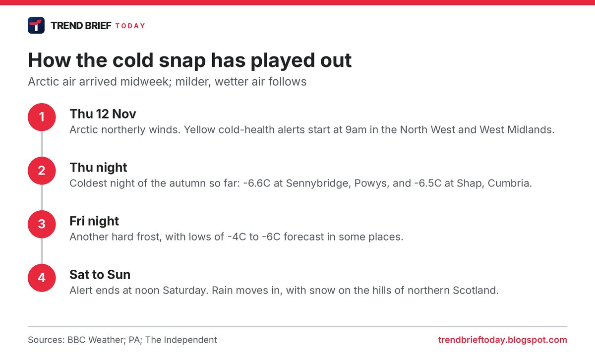
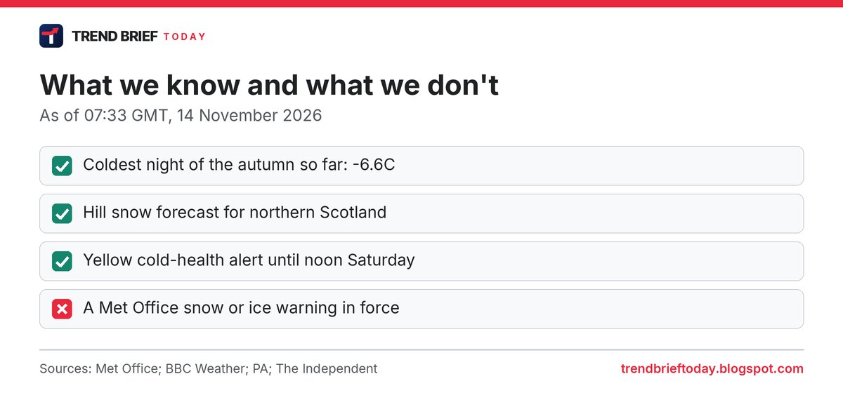
Northerly winds brought Arctic air across the UK on Thursday, giving some of the most widespread low temperatures of the autumn.[1][2] The coldest spot on Thursday night was Sennybridge, near Brecon in south Wales, at -6.6C, and the village of Shap in Cumbria fell to -6.5C.[1][2][3]
Friday night was forecast to be just as raw. "Overnight temperatures on Friday night will dip again to minus four or even minus 6C in some locations, meaning another significant ground frost for many locations," Met Office chief forecaster Chris Bulmer said, adding that daytime temperatures for most places would stay in single figures.[2][3] The Independent reported that lows of -6C were most likely in rural parts of southern England.[4]
Next week: rain, sleet and hill snow
The cold does not go away completely. The Met Office outlook for Sunday to Tuesday says: "Unsettled with spells of rain or showers Sunday and Monday. Rain in the south on Tuesday, with some hill snow possible. Brighter with showers elsewhere. Often windy and feeling cold."[5][7][8]
That is why some outlets have run lists of "areas facing snow". AOL and the Daily Express both reported that Met Office precipitation maps showed about 20 areas, mostly in Scotland, shaded for possible snow early on Monday, November 16.[6][7] These maps change with every model run, so treat them as a guide to where snow is possible, not a promise of settled snow in your street.
Is there a weather warning?
Snow warning now in force (November 17 update)
The yellow snow warning started at 00:00 on Tuesday, November 17. When we checked the Met Office warnings feed at 02:48 GMT, it ran until 11:00, an hour earlier than first issued.[16] UKNIP reports that the Met Office changed the warning on Monday morning, cutting back its southern and eastern edge and bringing the end time forward.[17] Some reports written before that change still say midday.[18][19]
| Region | Areas listed | Change from Sunday |
|---|---|---|
| Southern Scotland | Dumfries and Galloway, Midlothian, Scottish Borders, East Ayrshire, South Ayrshire, South Lanarkshire[16] | Still covered[13][16] |
| North West England | Cumbria, Lancashire, Greater Manchester, Blackburn with Darwen, Cheshire East[16] | Still covered[13][16] |
| North East England and Yorkshire | Durham, Northumberland, North, South and West Yorkshire[16] | Still covered[13][16] |
| Midlands | Derbyshire and Staffordshire[16] | Nottinghamshire no longer listed[13][16] |
The forecast amounts have not changed: 1 to 5cm where snow settles, mostly above about 100 metres, and 5 to 15cm on ground above 300 to 400 metres.[18][19] The snow should be short-lived. BBC Weather expects it to turn back to rain by about 09:00 in most places, and the Keswick Reminder, quoting the Met Office, says it will turn back to rain from the south through Tuesday morning.[18][19]
Higher roads are the main worry. BBC Weather names the A74(M), A66 and M62 as routes that could see problems, and the Met Office warns of disruption on higher-level routes and ice building up on power lines.[18][19] BBC Weather adds that wet, heavy snow and gusts of 40 to 50mph over high ground could bring down branches and cause some local power cuts.[18] The UKHSA cold-health alert for northern England stays in place until 09:00 on Thursday.[11][18]
Snow and ice warnings issued (November 15 update)
Yes, as of Sunday night. When we checked the Met Office warnings feed at 22:44 GMT on Sunday, it listed two yellow warnings.[13]
| Warning | When | Where |
|---|---|---|
| Yellow, ice | 18:00 Sun Nov 15 to 10:00 Mon Nov 16 | Highland, Grampian, Central, Tayside and Fife, Strathclyde, the Lothians and Borders, Dumfries and Galloway, Cumbria, Durham and Northumberland |
| Yellow, snow | 00:00 to 12:00 Tue Nov 17 | Southern Scotland, North East and North West England, Yorkshire, Derbyshire, Nottinghamshire, Staffordshire and Stoke-on-Trent |
The snow comes from a band of rain moving north on Monday night that is expected to turn to snow when it runs into colder air. The Met Office says ground above about 100 metres is most at risk, that snow lower down should not last, and that 1 to 5cm is likely where it settles, with 5 to 15cm possible above 300 to 400 metres. It warns of travel trouble on higher routes and ice building up on power lines.[14][15]
"We're likely again to see some significant and disruptive snow above 300 metres for northern England, above about 150-200 metres for southern Scotland," Met Office meteorologist Aidan McGivern said, adding that gusts of 50 to 60mph could bring drifting snow and blizzards on high ground. For most people, he said, "it will mostly be wet weather rather than wintry weather."[14] The ice warning is about icy patches on untreated roads and pavements after Sunday's rain.[14][15]
Saturday check
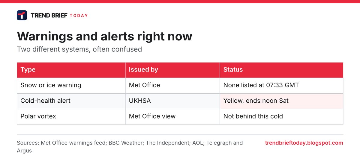
When we checked the Met Office's UK warnings feed at 07:34 GMT on Saturday, it listed no weather warnings.[9] The Met Office issues yellow, amber or red warnings for snow and ice when it expects impacts such as travel disruption, so it is worth checking again before a trip to the Scottish hills.
The alert that is in force is a different thing. The UK Health Security Agency (UKHSA) issued its first yellow cold-health alert of the winter for the North West and West Midlands, running from 09:00 on Thursday, November 12 to 12:00 on Saturday, November 14.[1][4][10] These alerts are about the risk to health, especially for older people, not about the weather itself.[1][10]
"This is the first cold-health alert of the winter, but we can expect more as we move further into the season," said Dr Anya Gopfert, consultant in public health at UKHSA. She urged people to check on friends, family and neighbours who are most vulnerable, including those aged 65 and over and people with existing health conditions.[3][4] For more on how the alerts work, see our explainer on the first cold-health alert of winter 2026-27.
New cold-health alert from Sunday night (November 14 update)
UKHSA issued a second yellow cold-health alert on Saturday. It covers the North West of England, the North East of England and Yorkshire and the Humber, and runs from 21:00 on Sunday, November 15 until 09:00 on Thursday, November 19.[11][12] Other regions of England are not covered.[11]
"This is the latest cold-health alert of the season, and we can expect more as we move further into winter," said Paul Coleman, consultant in public health at UKHSA. He asked people to check in on friends, family and neighbours who are most vulnerable, and to heat the rooms they spend most time in where they can.[11] The Independent reports the same regions and dates and notes temperatures had already fallen below -6C in some areas.[12]
| Alert | Regions | Dates |
|---|---|---|
| First (ended) | North West, West Midlands | Thu Nov 12, 09:00 to Sat Nov 14, 12:00 |
| Second (new) | North West, North East, Yorkshire and the Humber | Sun Nov 15, 21:00 to Thu Nov 19, 09:00 |
| Met Office warnings | None listed | Checked 16:52 GMT, Sat Nov 14 |
Is the polar vortex to blame?
No, according to the Met Office. It says this cold spell comes from a change in wind direction, as high pressure building to the west and north-west of the UK pulled in colder Arctic air from the north.[6][8] There has been warming in the stratosphere and a weakening of the winds around the polar vortex, but the Met Office says such changes can take weeks to affect weather near the ground, and any effect is not guaranteed.[6][8]
Keeping warm and the cost of heating
UKHSA advice is simple: keep your home heated where you can and dress in warm layers.[3][4] If you or a relative were born on or before 27 June 1960, this week is also when Winter Fuel Payments of £200 or £300 started arriving. Our Winter Fuel Payment 2026 guide explains who gets it and who has to pay it back.
Frequently asked questions
Where will it snow in the UK this weekend?
Mainly over the hills of northern Scotland, from Saturday evening into Sunday. Some snow could reach lower levels there for a time.[2][3][5]
Will it snow in England?
England is forecast to be mostly dry on Saturday, with rain and showers on Sunday. The Met Office outlook mentions some hill snow possible on Tuesday, when rain reaches the south.[5][8]
How cold did it get?
The coldest reading of the autumn so far was -6.6C at Sennybridge in Powys on Thursday night. Shap in Cumbria recorded -6.5C.[1][2][3]
Is there a new cold-health alert?
Yes. A yellow alert covers the North West, North East and Yorkshire and the Humber from 21:00 on Sunday, November 15 to 09:00 on Thursday, November 19.[11][12]
When did the first cold-health alert end?
The yellow alert for the North West and West Midlands runs until 12:00 on Saturday, November 14. UKHSA has said more alerts are likely as winter goes on.[1][3][4]
Is there a Met Office snow warning?
Yes. A yellow snow warning is in force from 00:00 to 11:00 on Tuesday, November 17, for southern Scotland, northern England, Derbyshire and Staffordshire.[16][17] It was first issued to run until 12:00, and a yellow ice warning covered Scotland, Cumbria and the North East until 10:00 on Monday.[13][14] On Saturday, November 14, no warning was listed.[9]
References
- BBC Weather (Ben Rich), Arctic air drops temperatures below zero as UKHSA cold health alerts in force, 12 November 2026.
- PA News Agency via Welwyn Hatfield Times, Temperatures could plummet as low as minus 6C overnight during cold snap, 13 November 2026.
- The Independent (Izzie Addison), UK braced for temperatures to plummet to minus 6C as Met Office issues warning, 13 November 2026.
- The Independent (Rebecca Whittaker), Arctic blast brings chance of snow to UK as temperatures plunge to -6C this weekend, 13 November 2026.
- AOL (Charlie Bradley), Met Office names 21 areas facing snow on Saturday, 13 November 2026.
- AOL (Jennifer Pinto), Met Office names 20 areas facing snow on Monday, 13 November 2026.
- Daily Express (Astha Saxena), Met Office forecast names 20 areas facing snow in hours, 14 November 2026.
- Telegraph and Argus (Joshua Searle), Met Office UK snow forecast this weekend as temperatures fall, 13 November 2026.
- Met Office, UK weather warnings (warnings feed checked 07:34 GMT and 16:52 GMT, 14 November 2026).
- GOV.UK (UK Health Security Agency), UKHSA issues first cold-health alert of winter 2026/27, 10 November 2026.
- UK Health Security Agency, GOV.UK, UKHSA cold-health alerts winter 2026/27 (latest update 14 November 2026).
- Harriette Boucher, The Independent, Met Office issue yellow cold weather health alert in UK as temperatures drop to -6C, 14 November 2026.
- Met Office, UK weather warnings (warnings feed checked 22:44 GMT, 15 November 2026).
- Georgia Bates, The Independent, Met Office says UK will be hit with snow within hours as travel warning issued, 15 November 2026.
- Dan Haygarth, The Independent, Weather mapped: Yellow alerts issued as snow set to hit with temperatures plunging to -4C, 15 November 2026.
- Met Office, UK weather warnings (warnings feed checked 02:48 GMT), 17 November 2026.
- UKNIP, Met Office issues yellow snow warning as up to 15cm forecast across parts of UK, 16 November 2026.
- Chris Fawkes, BBC Weather, Met Office yellow warning in place as snow could disrupt Tuesday morning travel, 17 November 2026.
- Keswick Reminder, Snow warning issued for Cumbria, 16 November 2026.
Image credits: Cover photo: Alan Reid, CC BY-SA 2.0, via Wikimedia Commons. The cover image is shared under the same licence (CC BY-SA 2.0).